The temperature never got much higher than the mid 40s today. When I left a month ago the temperature was 27F and when I arrived home at 11:25 AM the temperature was 42F. I am thinking I had no affect on the weather whatsoever.
Since I arranged to pay for the gasoline up front, I purchased no gasoline on the return trip from New Jersey.
I left New Jersey at 8:20 AM after the grandchildren had boarded the bus for school and met with rain just about all the way home. This concludes the first leg of my vacation trip this year with the second leg heading to the North Country to Maine and possibly Canada.
So I will be signing off now but hope to see everyone again in September. I also plan to summarize this trip in about a month when all the bills are in. So until then,
Thanks everyone!
The Traveller
Thursday, May 5, 2011
Tuesday, May 3, 2011
Day 28 - Another Jersey Day
The temperature warmed up a bit today as it topped out at 79F. It felt even warmer when I walked the Monmouth Battlefield State Park tour in the open fields.
No gasoline purchased today, thank goodness!
I spent a great deal of time taking the walking tour of the Monmouth Battlefield State Park. It was quite a jaunt as the path has not been mowed as yet, only from where it was the past season. The Battle that took place here on June 28, 1778 was one of the largest Battles of the American Revolutionary War. The two combatants were basically George Washington and Charles Lee. It is estimated that there were over 1100 British and 500 American casualties. I also spent a bit of time in Freehold and Caldwell, New Jersey visiting the birthplaces of Bruce and Grover Cleveland.
My trip is coming to a close as I am heading for home tomorrow. I am doubtful that anything will catch my eye as I have traveled this many times before but I will be on an extra lookout.
So I am saying goodnight to all!
The Traveller
Bruce Birthplace

This picture shows where Bruce lived during his early years in Freehold, New Jersey. It is basically the same house on the outside with the exception of new siding.
D'Annae: A French, Swedish-Style-4-Pounder

This replica of the D'Annae is shown at Monmouth Battlefield State Park in Manalapan, New Jersey. In 1777, the Continental Army was in desperate need of more field artillery. The French obliged the Colonists by sending 31 of these D'Annae to them. Eventually some of these 31 came to Monmouth Battlefield.
These D'Annae cannons require a large gun crew to move, load, point, and fire the gun, supply ammunition, and hold the horses. One of the gun crew was a female by the name of Molly Hays who carried the ammunition from the crew who filled haversacks with cartridges from the ammunition horses to the crew member who loads the cartridges. From this actual event came a 'Molly Pitcher' myth about a woman who was a water-carrier who took over firing canons after her husband had been killed.
Monday, May 2, 2011
Day 27 Morristown Revolutionary Day
Temperature remained in the 60s today with a high of 68F. Hopefully warmer weather is ahead.
I Purchased gasoline today at $3.799/gallon. I am really keeping a keen eye on the gas pumps these days.
I spent this afternoon in Morristown, New Jersey visiting Morristown National Historic Park. It consists of three sites, the Ford Mansion, Fort Nonsense, and Jockey Hollow that were important during the American Revolutionary War which began in 1775 and ended with the Treaty of Paris in 1783.
I am thinking that Monmouth Battlefield State Park might be on my agenda tomorrow.
Goodnight folks!
The Traveller
Ford Mansion

Located in Morristown, New Jersey, the Ford Mansion was used as George Washington's headquarters during December 1789 to June of 1790 to Map out Military Strategy in the Northern and Southern Theaters with the French. While this was happening, 10,000 of Washington's troops were gathering in Jockey Hollow to build huts and shelters. Dogged by hunger and biting cold, the soldiers spent most of their free time huddled around the fireplace. This Battle turned out to be one for the Environment.
Fort Nonsense Location

Although no records exist from historical times to tell us what the fortifications here looked like, archaeological evidence revealed the location of walls and ditches at this site. The stone markings in this picture show this outline of the walls and ditches that make up the redoubt or Fort Nonsense. George ordered the construction of this small fortification on the hill overlooking Morristown, New Jersey to protect his Army and supplies from a British attack. George was one who always looked for the high ground. As it turned out, the British never came and the fortification was never called on to defend the town.
Day 26 - Family Day
Temperatures again in the 60s but did feel a bit warmer when the sun shown through the clouds.
No gasoline purchased today.
I spent the day with the some of the family in New Jersey watching grandchildren playing softball and just hanging out with them. It was such an enjoyable relaxing day!
As suggested by Brian and Lori, I plan on going to Morristown, New Jersey this afternoon to visit Morristown National Historical Park.
Stay posted everyone!
The Traveller
Sunday, May 1, 2011
Day 25 - Brotherly Love Day
The temperatures were even cooler today as the high just made it to 70F.
I purchased gasoline at Fort Meade which cost me $3.889/gallon. I guess we are going to have to get accustomed to over $4.00/gallon cost. Someone is getting rich over this and it is not me.
I spent some of the day at Fort Meade, which is not recognizable at all to me, and I spent the remainder in Philadelphia. The City of Philadelphia has so much history about our country becoming a nation. As the guide said at Congress Hall that one of the most significant things that happened there was the swearing in of John Adams transferring the power peacefully from one individual to another. This transfer of power usually happens when someone died or when someone was ousted out of power through an overthrow.
My plans include spending some time with the grandchildren for the next few days. I do plan on looking for Revolutionary Battlefields while they are in school, however. Seems an awful lot of Revolutionary Battles were fought in New Jersey.
Al I plan to be at Thursday get together, so save a chair for me!
Take care everyone!
The Traveller
Congress Hall

Congress Hall is the building that served as the seat of the United States Congress from December 1790 to May of 1800. It was during this time that three (3) new states were admitted, Kentucky, Tennessee, and Vermont, both the Bill of Rights and The Constitution of the United States were ratified, and both George Washington and John Adams Presidential inaugurations were oversaw. This again is history folks.
Liberty Bell

The Liberty Bell, located in Liberty Bell Center in Philadelphia, Pennsylvania, is a symbol of American Independence. It has grown in stature over the years.
The Bell was originally called The Pass and Stow Bell, named for the two inexperienced local founders who offered to recast the Bell after the civic authorities sought a bell of better quality. It was not known what had caused the crack until 1975 when Winterthur Museum conducted an analysis of the metal. They concluded that a series of errors were made during the construction, reconstruction, and second reconstruction of the Bell. These errors resulted in a brittle Bell that barely missed being broken up for scrap. Basically they were saying that the tin and pewter used versus the pure copper which should have been used made it brittle. By the way its inscription reads "Proclaim Liberty throughout all the land unto all the inhabitants thereof". I believe this is a biblical verse.
The Benjamin Franklin National Memorial

Located in the Rotunda of Pennsylvania's most visited museum, The Franklin Institute in Philadelphia, this centerpiece is a dramatic 20 foot high marble statue of Benjamin Franklin. Designated by The United States Congress in 1972 as the official national memorial to Franklin, I believe it is the only National Monument in private hands. I do have to say be cautious of paying the fee of $15 to go into the Museum unless you brought children with you, however.
Just a tidbit of history, if anyone remembers Nelson A. Rockefeller, on April 12, 1976 the then Vice-President formally dedicated this memorial a National Monument. Benjamin Franklin is another one of our forefathers I hold in high esteem.
Fort Meade NOT
As one can see from the above picture my place of employment while in the service is no more. I drove into Fort Meade and did not recognize anything there. I did find that the unit I was with is still there and is still the Command Headquarters. It went from a wood building of yesteryear to a red brick building that it is today. It is unbelievable just how much it has changed since I was there almost 40 years. There was even a Burger King sign within the confines.
Saturday, April 30, 2011
Day 24 - Father of Our Country Day
The temperatures were a bit cooler but did reach 75F in the afternoon.
No gasoline purchased today as the driving mileage was kept to a minimum due to the traffic in Alexandria area.
I spent just about the whole day at Mount Vernon taking in George Washington's estate. He truly was a remarkable man. From the Farmer, Commander of the Continental Army, President of the Constitutional Congress, President of the United States, and his admiration of all his peers, it was no wonder that he is the only President to be elected unanimously. Where have you gone George Washington!
I am off to Philadelphia and the state of New Jersey tomorrow.
Until then everyone!
The Traveller
Looking out My Back Door

This picture shows George's view from the the back porch of the Mansion looking out over the Potomac River. I can see why George loved this place so much.
Mount Vernon Mansion

This picture taken of George Washington estate located near Alexandria, Virginia. When John Washington died in 1677, his son Lawrence, George's grandfather, agreed to formally divide the estimated 5,000 acres estate with the heirs of Nicholas Spencer. It was at this time the property would be named Little Hunting Creek Plantation and would remain so until 1742 when the estate would be renamed Mount Vernon. In 1752 Lawrence, George's half brother, passed away leaving George as executor of the estate. George then leased Mount Vernon until 1757 until he purchased the remaining interest of the property from his sister-in-law. In 1858, the Mount Vernon Ladies Association of the Union, under the leadership of Ann Pamela Cunningham, acquired the mansion from George's great-grandnephew, John A. Washington, Jr.
Friday, April 29, 2011
Day 23 - It's Revolutionary! Day
The temperatures were in the high 70s to mid 80s today with a high of 84F. It was extremely windy all day as there were threats of a tornado.
Gasoline purchased today came in @3.819/gallon today.
I spent the morning hours at Colonial Williamsburg. I chose not to purchase tickets for the tours of the houses, businesses, and loyalty places. I just walked around the town. I think it was a wise choice as Yorktown Battlefield was waiting in the wings. I was really impressed with the Yorktown Battlefield. This was basically the last battle between the Patriots/French and the British. Independence had finally come.
Mount Vernon is next on my list to do!
Have a joyous day tomorrow!
The Traveller
Grand American Battery

After capturing Redoubt 9 and 10, the Allies could then complete a second siege line and to construct a Grand American Battery as shown in this picture. From this position the Allies were within point blank artillery range of the British Inner Defense Line. On October 17, Continental artillery crews began bombarding the British from this battery. Within two (2) days the British were ready to negotiate a surrender.
Yorktown Battlefield - Redoubt 9

The picture taken here is of Redoubt 9 where on the night of October 14, 1781 the French stormed the British while the Patriots stormed Redoubt 10. The patriots attacked with unloaded muskets to ensure there would be no friendly fire. The claim is that only nine (9) men were lost in their charge. The French with loaded muskets lost fifteen (15). Amazingly low numbers when trying to maneuver around these.
Colonial Williamsburg, Virginia

This Historic Area is an interpretation of a Colonial City with exhibits including dozens of authentic or re-created colonial houses.
This picture taken of a horse and carriage on The Duke of Gloucester Street. The street was named after Queen Anne eldest son. One can see one of the many houses in the background.
Wednesday, April 27, 2011
Day 22 - "Wild Horses" Day
The temperature hovered in the low 70s until I crossed the Bridge-Tunnel where the temperature rose to 82F. I am not sure how or why this happened,however. I did experience some rain today but it was always short lived.
No gasoline purchased today thank goodness, as it still looks like it is in the high $3.80s.
I spent a greater part of the day on Assateague Island looking for the ponies, walking trails, and strolling along the beach on the Ocean side. I looked for some sea shells with very little luck. It was extremely windy on the beach and the shells were mostly broken. There was a 3/4 mile sand dunes trail that was quite interesting.
My plan is to go to Colonial Williamsburg and maybe Jamestown/Yorktown tomorrow.
Take care everyone!
The Traveller
Lucius J. Kellam Jr. Bridge-Tunnel

This picture, taken from island 1 looking Northeast, is of the Bay where water flows over the Thimble Shoal Channel Tunnel. There is a Sea Gull Pier Restaurant and a Gift Shop where one can stop and have something to eat or buy some momemtos on this island. Does the family remember stopping there a few years ago? Better known as the Chesapeake Bay Bridge-Tunnel until 1987, the bridge-tunnel has a length of 23 miles linking the Delmarva Peninsula to Virginia Beach, Virginia. There are two one mile tunnels: one as is pictured and another between island 3 and island 4 on the Northern portion. All four (4) islands are man-made. From 1964 to 1999 there were only two lanes for automobiles to cross. In 1999 an additional two lanes were open for the bridge portion only. The tunnels portion still remain only two lanes. The depth of the water is between 25 to 100 feet all along the route. The cost of the entire bridge-tunnel is $450,000,000 with the original cost of the two lanes being $200,000,000. Each took a little under 4 years to construct.
I am thinking that Bridge pictures have replaced mountain pictures on this trip. By the way there is a cost of $12 to make the trip across the bridge-tunnel.
Chincoteague Ponies
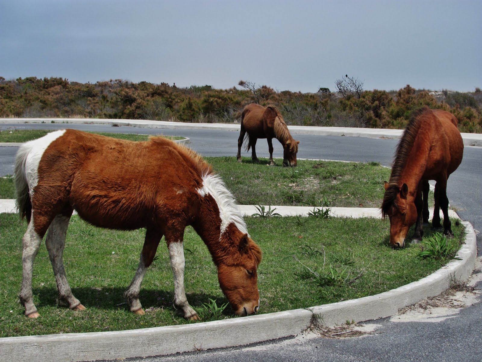
This picture shows some of the different colors of the ponies. They are either one solid or pinto color. Today most people think that the wild ponies on Assateague Island are descendants from domesticated stock which grazed on the island as early as the 17th century by eastern shore planters. The farmers grazed their ponies and other livestock here to avoid the mainland taxes and fencing requirements.
I was told by one of the aids on bicycle duty that there are approximately 115 ponies on the Maryland side.
Chincoteague Pony

This picture taken at Assateague Island National Seashore on the Maryland side. There are two herds (separated by a fence on Maryland Virginia border) of wild horses known as "ponies" who make their home on Assateague Island. The term "ponies" is due in part to their smaller stature, which was created as a result of poor habitat present on the island. As one can see in the picture the ponies are seen near the roads and campgrounds on the Maryland side. On the Virginia side one would probably find them in the Black Duck Marsh area away from the public access. The main reason for this is the Maryland ponies are owned by the National Park Service who let them run wild and the Virginia ponies are owned by the Chincoteague Volunteer Fire Company who allow them to graze on the Chincoteague refuge. Each year the Virginia ponies are rounded up with the foals sold at public auctions.
Tuesday, April 26, 2011
Day 21 - Take It Easy Day
Another fine day with the temperatures hovering around 85F. With the exception of a few days, the weather has been good on my trip.
Gasoline skyrocketed today as Maryland wants $3.899/gallon. I am thinking this is the highest so far, but I need to check my records.
This was a relaxing day for me. I really was a bit tired from the previous day activities in D.C. so I took it easy. I left in the mid afternoon for the Eastern Shore of Maryland and drove for about two hours.
I am heading to see the ponies tomorrow, which are on the Assateague Island.
Goodnight folks!
The Traveller
Victorian-era Home in Cambridge Maryland

This picture taken of one of many Victorian houses on High Street in Cambridge, Maryland. The term Victorian refers to a time period and not a style. Generally the time period is 1837-1901 or during Queen Victoria reign.
The city of Cambridge was settled by English colonists in 1684 and is one of the oldest colonial cities in Maryland. To show just how historic this city is one of the houses on High Street was built in 1739. The house was originally owned by a Reverend who then sold the home to a Maryland State Senator. I would say this house is one for the ages.
William Preston Lane, Jr. Memorial Bridge

This picture was taken from the Eastern Shore of the Bridge. As it is better known, The Chesapeake Bay Bridge is a dual-span bridge connecting the Western part to the Eastern part of Maryland. The original span, shown in the foreground, was opened in 1952 with the parallel span added in 1973 to accommodate increasing volumes of traffic. The original span is now being used for Eastern going traffic only while the new span is used primarily for Western going traffic. The spans are referred to "Eastbound span" and "Westbound span". This is where the Bridge becomes unique. The "Westbound span" actually has three (3) lanes of which one of the lanes can be used for either "Westbound" or "Eastbound" traffic depending on which direction the heavy traffic is heading. The "Eastbound" has only two (2) lanes. The spans are 4.33 and 4.35 miles respectively. The bridge is one massive structure.
Day 20 - D. C. (Dang Cool) Day
The sun is shining again as the temperature hit a high of 90F today.
No gasoline purchased again today!
Brian and I had a great day in D.C. today. We spent all day in the U.S. capital. The weather and the sites were top notch. The Capitol tour and the elevator ride to the top of the Washington Monument were a direct result of Brian. Along with this we stopped at National Museum of American History, Archives of the United States of America, and the Air and Space Museum. I was especially fascinated with the Archives building which displays the original documents: Declaration of Independence (DOI), The Constitution of the United States (COUS), and the Bill of Rights (BOR). Both the COUS and the BOR are readible, the DI is not. I could make out some of the signers, however.
I want to express my thanks to Kath and Brian for putting up with this old man. I had a chauffeur, a cook, lodging, laundry service, and just about every other thing I can think of. You guys were the best.
It is off to Maryland Eastern Shore today and whatever lies in store for me.
Take care and be safe everyone!
The Traveller.
1948 Tucker Sedan

This picture taken in the National Museum of American History. Preston Tucker's automobile was promoted as the first new car in 50 years. It's rear mounted engine and rubber suspension design was to provide more safety and to reduce noise, fumes, and vibration. The center headlight would turn with the front wheels. Collision protection was provided with a pop-out windshield, padded dashboard, and safety chamber for the front passenger. Only 51 of these cars made it to the road as production was halted due to financial problems.
Lincoln/World War II Memorial

This picture taken from Washington Monument looking Southwest showing the reconstruction, that is and has been going on, of the pool between Lincoln Memorial and World War II Memorial.
The Fresco (The Apotheosis of Washington)

This a picture of the dome area of the Rotunda. The Apotheosis of Washington was painted by Constantino Brumidi taking 11 months to complete at the end of the Civil War. Brumidi had worked three years at the Vatican during Pope Gregory XVI. Washington is depicted surrounded by 13 maidens in a inner ring with Greek and Roman goddesses.
Capitol Building

This is a little different view of the Capital Building. This is a majestic building to me. The tour of the Capitol Building essentially was of the center section called the Rotunda. Everyplace in the Capitol are designated as either S(for Senate) or H(for House), depending on whether they are North(Senate) or South(House) of the Rotunda. Within the Rotunda there is an area known as the Crypt. This was designated to look down on the final resting place of George Washington in a tomb below. Martha had different plans, however as his final resting place was Mount Vernon. The Crypt actually houses exhibits on the history of the Capitol.
Sunday, April 24, 2011
Day 19 - Virginia Civil War Day
It was a very pleasant day today as temperatures hit a high of 89F. As one can see in the pictures the sun was out again also. I think I am actually getting use to the warmer weather.
No gasoline purchased today!
I spent most of the day visiting the Fredericksburg Battlefield. This was the most bloodiest Battle of any of the four (4) in this area. I find it amazing on just how loyal the soldiers were to their Commanders. I do not feel that this loyalty would happen today and I am not sure one could ask that of anyone.
I am off tomorrow for a tour of the Capitol Building compliments of Brian. Brian you are awesome!
I trust everyone had a Happy Easter!
Goodnight everyone!
The Traveller
Stonewall Jackson Shrine

The Stonewall Jackson Shrine is the plantation office building near Guinea Station where General Thomas J. Jackson died on may 10, 1863. The office was an outbuilding on Thomas C. Chandler Fairfield plantation. This truly was a huge blow to the Confederates.
Stone Wall/Sunken Road at Fredericksburg, Virginia

On December 13, 1862, the Confederates from behind this reconstructed stone wall met charge after futile charge from the Union. When it was all finished there were over 7000 Union soldiers either killed or wounded before the foot of Marye's Hill. As Confederate General Longstreet stated "The Federals had fallen like the steady dripping of rain from the eaves of a house".
Saturday, April 23, 2011
Day 18 - Virginia President Day
When I woke up today, the temperature was in the 50s but the temperature did top out at 75F. In addition the sun reared its shiny head part of the day.
I Purchased gasoline at $3.569/gallon today. I am thinking that this might be the cheapest price yet.
I spent a good part of the day at James Madison Montpelier Estate today. It was quite interesting to me as no one really talks much about him in the history books except he was President number 4. The Manor has a bit of Monticello in it, probably because Thomas Jefferson loaned Madison his architect. A bit of trivia on James Madison, he entered the College of New Jersey and graduated with a Princeton degree. The college it seems changed its name during the time he spent studying there. I did get to see some of Fredericksburg and Spotsylvania County Battlefield later in the day. I will post some of these Battle Site pictures in tomorrows blog and then I'm off to visit some of my family.
I want to wish everyone a Happy Easter tomorrow.
Night folks!
The Traveller
James Madison Montpelier

James Madison Montpelier Manor House is located a few miles South of Orange, Virginia. The land was purchased by James grandfather Ambrose Madison in 1723. In 1764 the original House was constructed. When James Madison inherited the land and House from James Sr. in 1801 the House was modified with a 30 foot extension and a Tuscan portico. The Estate was sold in 1844 upon the death of James Madison in 1836 and the relocation of his wife Dolley to the Washington, D.C. area.
The DuPonts in the 1900s added additional wings that more than doubled the size of the House. In 1983 Marion DuPont willed the property and $10 Million to maintain it to the National Trust for Historic Preservation.
In 2003-2008 the House was restored to the Montpelier appearance of the 1820s.
Day 17 - The Vander-bilk Day
Today's temperatures was mostly in the high 40s but did reach a high of 63F. It rained, on and off, most of the day. I guess I got use to the 80s I was seeing.
Gasoline prices fluctuated as I purchased some for $3.759/gallon near Asheville, North Carolina and some for $3.599/gallon just outside of Greenville, Virginia.
I spent most of the morning at Biltmore Estates and then traveled to John's in the afternoon. It was good seeing John again and I would like to thank both John and Marcia for allowing me to stay the night. They are always hospitable.
James Madison Montpelier and Fredericksburg and Spotsylvania County Battlefields are next on the list.
Hope everyone is having a fun Easter weekend.
The Traveller
Cedric's Tavern

This was taken of the newly constructed Cedric's Tavern that is part of the Village Green. The tavern was completed in 2010 and is named after Cornelia's dog Cedric. Cornelia was George II only child.

Biltmore House

As one can see in the picture the Biltmore House should have been called the Biltmore Chateau. The house, located near Asheville, North Carolina, was built between 1889 and 1895 by George Washington Vanderbilt II. George the II was the great grandson of Cornelius "The Commodore" Vanderbilt the Railroad mogul.
One can take a self-guided tour of many of the 250 rooms which include numerous bedrooms for guests, library room, living rooms, game rooms, a weight room, swimming pool, servant quarters, and 43 bathrooms just to name a few.
Thursday, April 21, 2011
Day 16 - Smoky the Bear Day
Last night's rain seemed to have brought down this mornings temperature. The temperature did reach 76F today but it was a bit cooler on the Mountain.
Gasoline purchased today was at $3.659/gallon. This is a bit higher than the $3.619/gallon from a few days ago, but it is still not like prices up North.
I spent most of the day trekking up the two (2) mile hike to the top of Chimney Top Mountain. I was tired when I got to the top but the exercise was good for me.
I am off to Biltmore Estates tomorrow to see how the better half lived in yesteryear.
Three Day Weekend everyone!
The Traveller
Chimney Top View

This was a pretty awesome sight once one trekked to the top. One has to walk up a two (2) mile trail to the top of Chimney Top Mountain, taking about three (3) hours round-trip. I only wished it had been a bit less hazy to better show just how beautiful it was. Pictures seem to magnify the fog.
Carlos C. Campbell Overlook - Great Smoky Mountains

Named after the Director of Commerce of the 1930s, this picture taken in the Sugarland Mountain area. It is amazing just how many different types of trees there are here including Red Spruce, Northern Hardwood, Hemlock, Cove Hardwood, Mixed Oak, and Pine-Oak to name a few.

Wednesday, April 20, 2011
Day 15 - Chattanooga Two-Two Day
Woke up this morning with thunderstorms and pouring rain outside. The rain never subsided until 10:00 AM. By noon the roads had dried and the rains never returned. The temperature topped at 78F in the early afternoon.
No gasoline purchased today as I stayed in Chattanooga to visit other sites of the City.
I spent a few hours at both the River and Ocean Aquariums, visited downtown Chattanooga where the Chattanooga Choo-Choo resides, and drove up to Point Park National Park to tour the Battlefield site.
I am off to the Great Smoky Mountain National Park tomorrow and possible visit the Biltmore winery (are you listening Jennifer and Kathleen?) in Asheville, North Carolina.
Hump day is over everyone!
The Traveller
Rock City on Lookout Mountain

This picture taken of Rock City on Lookout Mountain, Georgia. Its claim to fame is that from Lover's Leap, a point in Rock City, one supposedly can see a total of seven (7) states.
Upside-down Jellyfish

This picture taken at the Ocean Tennessee Aquarium located in Chattanooga, Tennessee is of an Upside-down Jellyfish. The Upside-down Jellyfish is quite different than most jellyfish as it rests upside-down on the sea floor and rarely swims. They are found in shallow tropical waters off Hawaii, Indo-Pacific, Caribbean, and the Gulf of Mexico coasts. They will grow to a 12 inch diameter when fully grown. There diet includes food acquired from algae.
Chattanooga Choo-Choo NOT

The first passenger train that linked the North to the South was named the Chattanooga Choo-Choo. It left Cincinnati, Ohio for Chattanooga, Tennessee on March 5, 1880. The Choo-Choo was operated by the Cincinnati Southern Railroad, America's first Municipal Railway System.
In 1941 the movie "Sun Valley Serenade" featured a song by Glenn Miller titled "Chattanooga Choo Choo" which told of a story of a train trip from Pennsylvania Station in New York City through Baltimore, North and South Carolina, and terminating at track 29 in Terminal Station in Chattanooga, Tennessee.
The Passenger Trains stopped operating in 1970 when passenger traffic dwindled.
Day 14 - Explorer Day
Another warm day as the temperature rose to 86F today with sunshine on my shoulder.
Gasoline prices continue on their downward trend as I paid $3.619/gallon today. Any breakthrough up North yet?
I spent a great deal of time visiting the Chickamauga Battlefield today. This certainly was a significant battle of the Civil War, especially on the western front.
I also explored the Ruby Falls Cave in Lookout Mountain. It was amazing that by drilling through the mountain that Lambert discovered this beauty.
My plan is to stay in Chattanooga for another day as there is quite a bit to see here. It is just unbelievable the way the Tennessee River winds around the City.
Until later take care everyone!
The Traveller
Ruby Falls

This picture taken inside Lookout Mountain in Ruby Falls Cave in Chattanooga, Tennessee. In 1905 the natural entrance to Lookout Mountain Cave was closed during construction of a railway tunnel. In 1920 a chemist and cave enthusiast named Leo Lambert formed a company to re-open the cave as a tourist attraction. After purchasing the land, he began to drill through the limestone and discovered about an 18 inch high and four feet wide passageway. Exploring the opening, Lambert discovered the formerly hidden Ruby Falls Cave and its waterfall. Rumor has it that his wife accompanied him on the 17 hour trip and told her he would name the falls after her.
In 1975 a secondary exit from the base of the falls was cut in the event the elevator failed. Good idea huh!
Brotherton Cabin

Pictured here is the reconstructive cabin of George and Mary Brotherton who farmed in the area. There is a neat story here as Tom, one of the sons of George and Mary Brotherton, was used as a scout for Lt. General Longstreet and played a significant role in the Confederate victory here.
It is hard to imagine so many living in this size cabin. Today some children have their bedrooms this size.
Chickamauga Battlefield

This is the site from Chickamauga Battlefield where Confederate Lt. General Longstreet's troops attacked from the woods across Lafayette Road, past the Brotherton Cabin, and across the field and into the newly created gap. The gap was created as a result of the Union Brigadier General Rosecrans receiving an erroneous report that Union Brigadier General Brannan's division had moved out of position, thus creating, it was believed, a gap in the federal Line. When Union Brigadier Wood division was ordered to fill that supposed gap, he created a real one. Doesn't appear that the left hand was talking to the right one.
As one can see from the picture the Battle of Chickamauga, September 19-20, 1863 dates, was fought mostly in a wooded area. The battles was the most significant Union defeat in the Western Theater and involved the second highest number of casualties in the war following the Battle of Gettysburg.
Day 13 - Back to the Simple Life
The temperature climbed back to 85F today (Monday) with a lot of sunshine. I must admit I have seen a great deal of sunshine down here.
Gasoline prices came in at $3.729/gallon today. Still far from the best, but the prices are going in the right direction.
I spent a very relaxing night in Plains, Georgia, however as one can see I am late on my posts for Monday. The hotel I stayed in had internet but I could not get connected at all.
It is quite interesting how a man could become President from such a small town. I am not sure this will ever happen again, however. He must have liked the town though as he built a new home in 1981 and has resided here ever since. He even teaches Sunday School at Maranatha Baptist Church on some Sundays.
My plan is to shoot up North to Chattanooga, Tennessee next.
Sayonara everyone!
The Traveller
Plains, Georgia

This picture taken of the town of Plains, Georgia. As one can see Jimmy Carter's name is plastered all over. To my rear and to the right is the Billy Carter (Jimmy Carters brother) Phillips 66 Gas Station that was made famous as a result of Jimmy Carter becoming President. As of the 2000 census, the population of Plains was 637 residents.
39th President Headquarters

From this depot in Plains, Georgia in 1975, Jimmy Carter, Jr. launched a two year campaign for the presidency of the United States. Referred to as "Jimmy Who" in the beginning of the campaign, Carter was inaugurated as America's 39th President on January 20, 1977. Prior to Carter becoming President he served as Senator and Governor of the State of Georgia.
Monday, April 18, 2011
Day 12 - Its a Navy Day
The temperature took a drastic turn today when I awoke to a temperature of 57F. The temperature never did get above 75F today.
The gasoline prices took a lesson from the temperature but not quite as drastic, as the prices came in at $3.759/gallon.
I spent the entire day driving to Pensacola and visiting the Naval Air Base in Pensacola, Florida. The National Naval Aviation Museum, The Pensacola Lighthouse, and Fort Barrancas were all stops on the day. The Museum had some interesting planes, one in particular was Amelia Earhart and the Lockheed Model 10 Electra. This was the plane which Earhart attempted to make a circumnavigational flight of the globe in 1937. As everyone knows she disappeared over the central Pacific Ocean near Howland Island. She truly was an inspiration to all (especially woman) over the world.
I am off to Plains, Georgia today to see if I can find a Peanut Farmer.
Back to work people!
The Traveller
Fort Barrancas - Water Battery

The Fort was originally built in 1787 as Fort San Carlos de Barrancas and used by the Spanish. The Fort did not come under U.S. rule until 1821, when it was renamed Fort Barrancas. It was during the 1839-1844 when the wooden hill-top structure was replaced with a massive brick fortress connected via tunnel to the battery. Stronger cannon and ironclad ships developed during the Civil War made masonry forts like Fort Barrancas outdated. As a result, the Fort was used as a signal station until 1946. In 1947 the Fort was deactivated, and the U.S. Navy incorporated the site into Naval Air Station Pensacola. In 1971 the Fort became a part of U.S. National Park Service.
This picture was taken of the Water Battery. Seems the Spaniards cannon fire from this point would literally skip across the Bay to hit ships at the waterline. This was a real neat Fort and well kept. Are you listening Fort Zachary Taylor people.
Pensacola Lighthouse View

This picture taken 191 feet above sea level from the Pensacola Lighthouse. One is looking Southeast into the Pensacola Bay. There is exactly 177 steps to the top of a spiral stairway. One must remove their sandals in order to climb to the top. I chose to change to sneakers.
Pensacola Lighthouse

This Pensacola Lighthouse, located in Pensacola, Florida, was Lit in 1859 and is still in use at the present time. This Lighthouse replaced the original Lighthouse built in 1824, the first Lighthouse on the Gulf Coast.
Decomissioned F-18

This picture taken at the National Naval Aviation Museum (NNAM) in Pensacola, Florida. This particular F-18 is being retired. The NNAM shares its home with the United States Navy's Blue Angels Flight Demonstration Squadron. During the 2011 season, the Blue Angels will perform practice air shows over NAS Pensacola most Tuesday and Wednesday mornings at 8:30AM.
Saturday, April 16, 2011
Day 11 - University Day
Temperatures in Florida have subsided a bit to a high of 85F. That breaks the trend of 90 for so many days. It was quite breezy driving westward on Route 10, it felt like I was driving behind a semi most of the way. Gasoline purchased today was again at $3.799/gallon.
I spent a good deal of time visiting the campuses in Gainesville and Tallahassee today, specifically the football stadiums. Each stadium has its own unique features. There was a surprise guest at Florida State, Jim Kelly was there with his son who evidently is a recruiter for the Seminoles. It was also nice to meet one of the 1999 FSU National Champions players. Thank you Ryan for being so informative on Seminole matters as well as being congenial to an outsider. This speaks well for the School.
I am off to Pensacola tomorrow to the National Museum of Naval Aviation and perhaps a Lighthouse.
Take care everyone!
The Traveller
Bobby Bowden Field at Doak S. Campbell Stadium - Tallahassee

University of Florida State Seminole Stadium in Tallahassee, Florida. Jim Kelly was found in Seminole territory.
Ray Charles Home

Located in Greenville, Florida, this house is a reconstruction of the home where Ray Charles lived with his mother and adopted grandmother, shortly after his birth in 1930, until about the age of five. It was at the age of seven that Ray lost his sight and he was sent to the Florida School for the Deaf and Blind in St. Augustine.
This house had no electricity or indoor plumbing. A hand primed pump supplied the water from a well next to the house. Because of deterioration, the abandoned house was scheduled for demolition in 2006 but the Town of Greenville purchased the structure to preserve the memory of Ray Charles. Completion of the reconstruction was done in 2008.
Ben Hill Griffin Stadium - Gainesville

University of Florida Gator Stadium in Gainesville, Florida. Tim Tebow was nowhere to be found.
Friday, April 15, 2011
Day 10 - Am I A Floridian?
Temperatures once again hit 90F, it has become a staple here in Florida.
Gasoline prices remained steady today at $3.799/gallon. Have the prices up North leveled off?
I was a bit late in getting on the road today, it must be a retirement thing.
I wanted to mention on yesterdays post that I left Key West with a total of 1823 miles travelled. This is a far cry from last years trip. I believe I left my end destination with over 6350 miles. I am thinking the gasoline bill may be the same though.
I am off to Gainesville tomorrow to see if Tim Tebow has returned and then head westward to Tallahassee.
I trust that everyone weekend will be a pleasant one.
Until then!
The Traveller
The Bob Graham Sunshine Skyway Bridge

The Bob Graham Sunshine Skyway Bridge is a bridge spanning Tampa Bay, Florida connecting St. Petersburg in Pinellas County and Terra Ceira in Manatee County. Construction of this bridge began in 1982 and opened to traffic in April of 1987. It replaced an older bridge that was partly destroyed in a collision of a freighter (MV Summit Adventure) and a pier support column during a storm in 1980.
Henry Ford Winter Estate

In 1916 Ford purchased the adjacent property to Edison. In 1928 the original building was dismantled and reconstructed to what one sees in this picture. Ford only used this retreat two weeks in any given year up to and until his last visit in 1934. In 1988 the Ford estate was acquired by the City of Fort Myers and opened to the public in 1990. One can not enter into any of the rooms of the house as each entry way has a plexi-glass petition preventing one access. In 1891 Henry Ford went to work as an Engineer for the Edison Illuminating Company which was established by Thomas Alva Edison in 1880.
Thomas Alva Edison Winter Estate - Seminole Lodge

In 1885 Edison purchased the property in Fort Myers, Florida to construct what was to become his winter home. This house, completed in 1887 and named "Seminole Lodge" was to be his retreat until his death in 1931. In addition Edison built another house that was to be used for his guests and a laboratory for experiments on these same grounds. In 1947 Edison's wife Mina deeds the Edison Estate to the City of Fort Myers for $1.00.
Banyan Tree

The Banyan Tree is a Tropical Fig Tree originated from India. Older Banyan trees are characterized by their Aerial prop roots that grow into thick woody trunks. Old trees can spread out laterally using these prop roots to cover a wide area. The very first Banyan tree planted in the United States was at the Edison and Ford Winter Estates in Fort Myers, Florida. It now covers a 400 feet area.
The Banyan Tree pictured is located on the same Edison and Ford Winter Estate adjacent to the Caloosahatchee River.
Day 9 - Everglades Day
The temperature again rose to 90F today but just west of Weston, Florida rains came at about 5:00 PM and cooled the temperature to 75F. Within a half-hour the sun came back and it ballooned back to high 80s.
I purchased gasoline today at $3.799/gallon in Key Largo. I think the days of less than $4.00/gallon cost are fading.
It was quite interesting going through the Everglades National Park today. I have a new understanding of just how these particular lands work. I will say this I thought there would be a lot more waters in the area; however.
Today, I have nothing particular planned but to drive North on the Western part of Florida on my way to Tallahassee.
Have a safe day everyone!
The Traveller
Everglades National Park - Sawgrass Prairie

The Everglades National Park, unlike other National Parks, was created to protect a fragile ecosystem instead of safeguarding a unique geographical feature. The Everglades are wetlands created by a slow-moving river originating in Lake Okeechobee fed by the Kissimmee River. Although humans have lived in the Everglades for years, not until 1882 was the region drained for agricultural or residential use. It wasn't until 1934 that the park was established to protect the quickly vanishing Everglades from the canal-building projects that diverted the waters from this area. As one can see from the picture of the Sawgrass Prairie it appears that not all has been done that can be done to protect this area.
Subscribe to:
Comments (Atom)